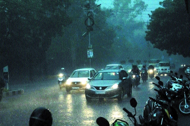
Week begins with heavy rains for State capital
| Date :09-Sep-2019 |
In next twenty-four hours, thundershowers along with heavy rains is predicted for city
Sunday morning started with heavy rains in State capital, which witnessed a brief break during noon time to again start in evening. In last twenty-four hours, rain showers were witnessed at many parts, including Sagar, Chambal, Gwalior division experiencing heavy or very heavy rainfall.
Rainfall recorded in various areas includes Bichiya at 18 cm, Malajkhand at 12 cm, Mandla at 18 cm, Kareliat 11 cm, Seoni at 9 cm, Morena and Amarkantak at 8 cm, Gotegoan, Narsinghpur at 7 cm, Ghansaur, Tendukheda, Alirajpur, Kannuj and Ambah at 6 cm.
Bhopal recorded 83.5 mm rainfall. Maximum temperature was at 27 degree Celsius and minimum temperature was at 23 degrees Celsius. Wind velocity recorded was at 14 km per hour. Most areas in city were clouded. In next twenty four hours, thundershowers along with heavy rains is predicted in city.
Rainfall is likely in many areas of State, including Anuppur, Umaria, Shahdol, Chhindwara, Jabalpur, Mandla, Katni, Narsinghpur, Hoshangabad, Bhind , Damoh , Rewa, Satna, etc. As per Weather Department, only two districts - Sidhi and Shahdol - are experiencing rains below normal. Rest of the areas in State are either receiving normal or above normal rainfall till date. G D Mishra, meteorologist from Meteorological Department, said, “The factors affecting weather in Madhya Pradesh are mainly the low pressure area formed in northern Chhattisgarh and adjoining areas as well as the upper air circulation is formed. The upper air system is upto altitude of 7.6 km, with a tilt towards southwest direction. The second monsoon system is throughout Jamshedpur area to Bay of Bengal, reaching height of 2.1 km. The third system is formed at 21 degrees North and cyclone at Saurashtra at a height of 3.1 km. All these systems are resulting in heavy to heavy rains in most parts of the State, including Bhopal.
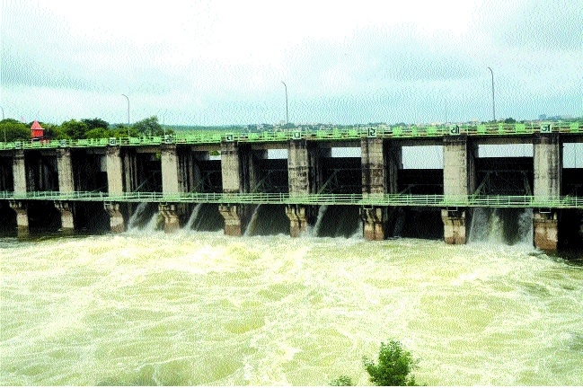
Most of the rivers in the State are in spate. The opening of Bargi gate at Narsinghpur is also increasing the water level in Narmada and tributaries. Lower settlements are being evacuated here. Barna Dam gates have been opened in Raisen district. In Damkheda village of the capital, the village has been evacuated by filling Kaliyasot’s river water. The Meteorological Department has issued a warning of excessive rainfall in 32 districts of the State in the next 24 hours.
Weather Department has issued heavy rains warning in almost 20 districts of State, including Vidisha, Raisen, Sehore, Bhopal, Rajgarh, Hoshangabad, Betul, Harda, Burhanpur, Khandwa, Khargone, Barwani, Dewas, Shajapur, Ashoknagar, Sheopur, Rewa, Satna, Anuppur, Dindori, Jabalpur, Narsinghpur, Chhindwara, Seoni, Mandla, Balaghat, Panna, Damoh, Sagar, Chhatarpur, Tikamgarh and Guna. Rains will remain intense in major parts of the State till September 15 .Heavy rains in State capital resulted in water-logging, including Panchsheel Nagar and Naya Basera township witnessing floods Three gates of Bhadbhada Dam and five gates of Kaliyasot have been opened due to heavy rains. Due to the opening of the gate of Kaliyasot, the slums colony was flooded in Damkheda B-sector of Kolar. On being informed, the Bhopal Municipal Corporation officials reached the spot and evacuated the area safely. The Kolans River filling the path of Bhadbhada Dam is running 5 feet, the river is expected to rise further.
The water level in Narmada and tributaries is also increasing with the opening of Bargi gate in Jabalpur. As per Weather Department, the Gwalior district broke its seven-year record of rains in the first week of September as the system moved towards Madhya Pradesh and became active in Gwalior-Chambal division, Morena, Bhind, Datia due to the formation of low pressure area in the Bay of Bengal.