CCOST, NESAC start drone survey for mapping Nuzul area in Sarangarh
| Date :12-May-2021 |

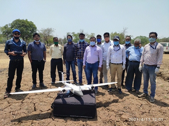
Teams of CCOST and NESAC Meghalaya in Sarangarh of Raigarh district during the survey.
By Abhishek Kumar :
RAIPUR,
Map of Nuzul area in Sarangarh being prepared on 1:500 scale
Drone survey technology being used first time to generate cadastral map in C’garh
Chhattisgarh Council of Science and Technology in collaboration with North Eastern Space Applications Centre (NESAC), Umiam Meghalaya; Indian Space Research Organisation (ISRO) and Revenue Department, Government of Chhattisgarh has started drone survey for mapping of Sarangarh Nuzul area in Raigarh district of State. Speaking to ‘The Hitavada’, the senior scientist of the CCOST M K Beg said that the CCOST in collaboration the NESAC and ISRO has recently started generating a high precision true digital orthophoto map, based on UAV images, for mapping of Nuzul area on 1:500 scale in Sarangarh area of Raigarh district. The project will be completed within one year, he added. Beg said that the Council in collaboration with the NESAC is using the drone survey technology for the first time in Chhattisgarh to prepare the cadastral map.
The existing map of the Nuzul area in Saragarh is not properly maintained and most of the information is missing in the map. So the Revenue Department in collaboration with the CCOST has decided to generate map of Nuzul area in Sarangarh by using high resolution drone images map on 1:500 scale, Beg added. Drone survey of around 15 square kilometres Nuzul area in Sarangarh is being carried out. Very high resolution drone images are the best input sources for large scale mapping. In this project, drone images are being used for mapping. Drone images will be procured with support of the NESAC Umiam Meghalaya. The outer village boundaries along with the location of bi-junction and tri-junction points are to be extracted from digital cadastral map and transferred to the orthoimage by geo referencing the cadastral map with orthoimage. The plot boundaries or vectors will be interpreted by onscreen digitisation method from drone orthoimage with precision following segmented approach. The vectors are drawn for the plots, which are clearly visible on the image in the first instance.
The plots whose boundaries are obscured because of tree canopy and other reasons are not closed will be dealt as difficult areas. These difficult area polygons and settlement areas are to be finalised by field survey technique using Differential Global Positioning System (DGPS). After field verification, the habitation polygons are to be incorporated. Road and other objects like pond, drain, tank etc. will be extracted from enhanced drone orthoimage. A pre-field map will be generated in 1:4000 scales for ground validation and DGPS based data collection. The pre-field map will be used for DGPS survey for the obscure areas where existing ground control co-ordinates will be used for the measurement of co-ordinates in the obscure areas.
The co-ordinates will be transferred to the plot vector geo-database for the finalization of complete plot vector extraction of the village falling in the urban area. The plot numbers will be transferred from the geo-referenced cadastral map and generate unique plot number. Records of Right (RoR) data for Sarangarh urban area villages then linked with plot vector for finalization of the geo-database on 1:500 scale by integration of village with khasra layers and layouts of streets, roads, infrastructure, plots and physical features on sites. The senior scientist said that CCOST with establish professional grade drone survey unit with the support of NESAC and the ISRO. The NESAC has state-of-art unmanned aerial vehicle (UAV) lab facility and UAV systems and has vast experience in UAV data capturing, processing, analysis and training.
The CCOST has initiated procurement of drone (UAV) for large scale mapping of urban infrastructure mapping for various line departments of the State. The NESAC has extended support to various State Remote Sensing Centers of NESAC for establishment of UAV facility. There is also an ardent need to build capacity to capture and process UAV data and promote the use of drones for potential UAV services to various departments within the state, he added. The senior scientist said that village level survey using high resolution drone images helps immensely in improving cadastral data base and house hold related mapping issues. The CCOST has already implemented such village level mapping in 12 villages of Raipur and Dhamtari districts including two Sansad Adarsh Gram under Village Information System (VIS) project sponsored by Department of Science and Technology, Government of India, he added.