Remote sensing maps 850 sand mining locations in district, none found viable
Date :19-Nov-2026
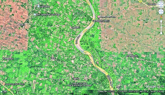
Satellite image of Kanhan river basin showing MRSAC-marked probable sand mining locations (in yellow). Markings in green are ‘Khasra’ demarcations (Pic credit: MRSAC)
By Rohit Pawar :
A significant gap between satellite-based identification and ground reality has emerged in the process of locating potential sand-mining sites in Nagpur district. The city based Maharashtra Remote Sensing Applications Centre (MRSAC) identified around 850 potential locations across the district.
However, none of the 16 locations shortlisted after successive screening rounds was ultimately found suitable for sand extraction for this year (2026-27) during field inspections.
According to a Mining department official, the exercise began with the identification of 850 locations through MRSAC’s satellite-based assessment.
After applying prescribed norms, the Mining Department
shortlisted 152 sites for further assessment. Talathis were deputed to each location to verify the availability of sand and assess the quality of potential mining ghats. Following these local inspections, the list was narrowed to 16 locations, informed the official.
District officials subsequently visited all 16 shortlisted sites for a final assessment but did not find any worthy of being taken up for mining.
The MRSAC document for 2026-27 provides geographical details of the 16 shortlisted entries, including village names, parcel numbers, coordinates and area measurements. These are spread across four talukas -- Saoner, Parseoni, Kamptee and Kuhi -- and cover a combined mapped area of approximately 98.66 hectares.
The outcome highlights the challenge of translating satellite-based resource mapping into viable mining locations. It also brings into focus whether the parameters used to identify potential sand deposits require further refinement to improve the accuracy of preliminary screening.
MRSAC uses
satellite imagery and GIS for resource mapping
Headquartered in Nagpur, MRSAC is an autonomous institution under the Maharashtra Government’s Planning Department. It specialises in remote sensing, Geographic Information System (GIS) and geospatial technologies for mapping and monitoring natural resources.
Depending on the project, it uses imagery from different satellite platforms and integrates it with GPS-based surveys and other geospatial data.
Meanwhile, Atul Daud, District Mining Officer, Nagpur, said the technology should not be blamed for the outcome. “Remote sensing and GIS provide preliminary indications rather than confirmation of the actual quantity, quality or extractability of sand directions. Ground checks are always necessary before confirming a location,” he explained. The district’s exercise illustrates why satellite-based mapping and field verification need to work together before a location is declared suitable for extraction.