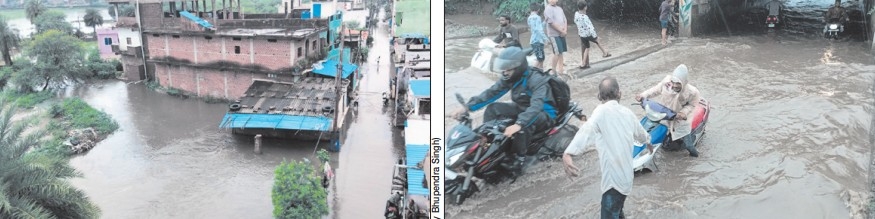
DELUGE @6.9 inches, Capital records 175.6 mm of rain as heavy downpours lash State; Sehore recorded extremely heavy rainfall at 210.0 mm ■ Kolar and Arera Hills recorded 158.4 mm and 151.0 mm respectively ■ Schools remain closed across district on Monday
| Date :11-Aug-2026 |
Staff Reporter :
BHOPAL experienced intense
rainfall, recording a massive 175.6
mm of downpour. Key localities
across the State capital witnessed
severe spells, with Kolar recording 158.4 mm and Arera Hills
logging 151.0 mm. Neighbouring
regions also bore the brunt of the
deluge, with Shyampur in Sehore
recording extremely heavy rainfall at 210.0 mm, followed by
Sarangpur (190.8 mm), Mohgaon
(187.2 mm), Sehore town (170.0
mm) and Sihora at 165.3 mm.
Across the State, rainfall occurred
at most places in Bhopal,
Narmadapuram, Ujjain, Gwalior,
Rewa, Jabalpur, Shahdol, and
Sagar divisions, while a few places
in Indore and Chambal divisions
also received showers. Other
areas recording intense spells
included Kalapipal (153.0 mm),
Aron (146.0 mm), Sultanpur
(143.4 mm), Pachore (140.0 mm),
Badi (134.0 mm), Harrai (133.6
mm), Begumganj (132.4 mm),
Sohagpur in Narmadapuram
(125.0 mm), Itarsi (124.2 mm),
Narmadapuram town (123.2
mm), Raisen (122.2 mm), Rehti
(118.6 mm), as well as Niwas and
Gairatganj with 117.4 mm each.
Furthermore, substantial heavy
rainfall was logged in Rajgarh
(112.5 mm), Raghogarh (112.0
mm), Lateri (106.4 mm),
Lakhnadon (104.2 mm), Budhni
(104.0 mm), Dolariya (103.0 mm),
and Pushprajgarh (98.8 mm).
Monsoon systems active over
State: According to the
Meteorological Centre, the continuous activity is driven by multiple persistent weather systems.
A low-pressure area over northern Madhya Pradesh persists
with an associated cyclonic circulation extending up to 5.8 km
above mean sea level.
The monsoon trough passes
directly through Datia and the
center of the low-pressure
system. Additionally, a shear zone
runs along latitude 22°N across
central India, while an upper-air
cyclonic circulation over the
northwest Bay of Bengal is
expected to form another lowpressure area around August 12.
Forecast and flash flood warnings:The Meteorological Centre’s
forecast for August 11 indicates
widespread rainfall across the
State, with rainfall expected at
most places across western and
northern districts including
Sheopur, Shivpuri, Neemuch,
Mandsaur, Ratlam, Ujjain, and
Agar-Malwa. Heavy rainfall,
lightning, and gusty winds (30-
40 km/h) are expected across
multiple districts under a yellow
watch. A low to moderate flash
flood risk has been issued for
watersheds in Agar-Malwa,
Mandsaur, Neemuch, Rajgarh,
Sheopur, and Shivpuri due to
potential surface runoff and lowlying inundation. For Bhopal and
its neighbourhood, the sky will
remain overcast with intermittent
spells of light to moderate rain,
thunderstorm, and lightning. Winds
are expected to average 16 to 18
km/h, with maximum and minimum temperatures settling around
26°C and 23°C respectively.