@@INCLUDE-HTTPS-REDIRECT-METATAG@@
PWD’s traffic count goes digital for first time in State
PWD’s traffic count goes digital for first time in State
By Sagar Mohod:
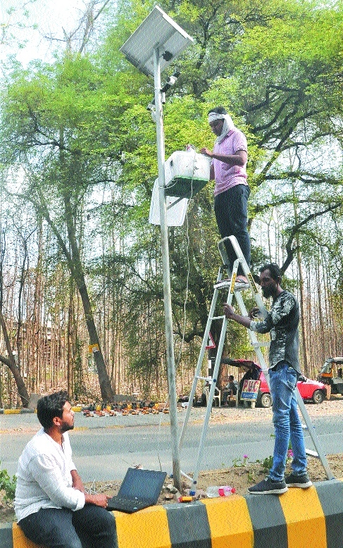
Public Works Department (PWD) has commissioned a traffic count of vehicles on roads using digital media for the first time in Maharashtra starting with Nagpur District. Called automatic Traffic Count and Classification (ATCC) it is currently on at four locations in city, namely Kriplani Turning (at tip of South Ambazari Road that meet Wardha Road), Seminary Hills (near Centre Point School), at Gittikhadan Square and Japanese Garden Square, said officials of PWD. All these are major intersection in Western part of city having thick traffic density and traffic count is held to plan for smooth flow past these squares and minimise the risk for road users.
A salient point of the traffic count this year is its digitisation, wherein flow of vehicles are monitored automatically using hi-speed cameras prefixed at vantage point. The exercise is held every odd year and till now measuring traffic flow was a manual exercise that lacked accuracy. But with digital recording of nearly every passing vehicle, the data generated is precise that form base for PWD to plan for future projects, said Vidyadhar Sardeshmukh, Superintending Engineer, PWD, Nagpur, while talking to The Hitavada. In case, Government needs to allocate funds or plan for any major project, the traffic count forms the base for it, he added further. Besides these four points in Division 1, other divisions too has identified points for traffic count.
Also the exercise is also being conducted at various places in the district on major road stretch as PWD is in process of putting together a major road expansion and networking plan due to rapid urbanisation in district. Traffic count is useful when PWD has to plan for laying a road network, to determine whether it needs expansion, especially if width is needed to be increased owing to increase in number of vehicles. Also it helps to determine whether the road needs strengthening as there is increase in flow of heavy vehicles and other technical aspects are also analysed during the survey.
Said J H Bhanuse, Executive Engineer, Division No. 1, PWD, Nagpur Region, with digital recording we now would have authentic data ensuring a better road planning from now on. Also the data when presented is base to help us carry out necessary modifications, if necessary on particular patches if the vehicle count has gone up substantially. So far manual count of vehicles used to be done where accuracy was always in doubt. But now videography of moving vehicles are done the data is automatically generated and software makes all the necessary calculation. According to information, the traffic count is conducted for a stretch of 15-days wherein vehicular traffic flow is measured with number of vehicles passing by through the particular stretch. Another aspect of survey involves segregation of vehicles, like number of two wheelers, four wheelers, trucks, buses etc. going past the selected points, stated Anil Deshmukh, Deputy Engineer, PWD.
City firm to aid in bettering intersections
The survey is being carried out by M/s Rajesh Motghare and Associates, a reputed name in the field of such precision work. The agency is credited with introducing the digital count to help PWD have an accurate measure of traffic flow to resolve flaws in manual counting. For it M/s Rajesh Motghare and Associates specially got the software designed from Chennai to map the traffic flow and present accurate data of traffic flow, it is learnt.
Traffic count is a study of flow of vehicles and its calculation is counted for passenger car unit (PCU), which measures of traffic density at particular road stretch or near the major intersection. For example at Kriplani Turning there is major component of cars while Gittikhadan Square witnesses a large movement of trucks. In the said exercise, one important assessment is measurement of axle load that forms base for determining the type of road needed to be constructed, its thickness, its width and usage of material to ensure it remains in shape. For example in case of swampy region, it is more particularly found in paddy grown area, the road width has to be extra thick as farms are water logged and extra water get percolated in to road.