NEERI completes first ever GIS-based mapping of Ganga
| Date :24-May-2021 |

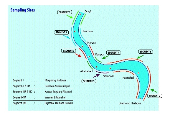
The majestic view of Laxman Jhula on river Ganga in Haridwar. (Right) The segment-wise mapping of the river Ganga from Devprayag to Diamond Harbour.
By Kaushik Bhattacharya :
The city-based Institute conducts mapping of Microbial Diversity
The study created the first ever baseline from the origin at Devprayag and right up to Diamond Harbour
CSIR-National Environmental Engineering Research Institute (CSIR-NEERI), Nagpur added a feather in its cap by conducting the largest and first ever GIS-based mapping of Microbial Diversity of river Ganga recently. An enthusiastic team with the partnership of four other institutes including Motilal Nehru National Institute of Technology (MNNIT), Allahabad; Charotar University of Science and Technology, Changa; PhiXgen Pvt Ltd, Haryana; and Xcelris Labs Ltd, Ahmedabad have taken on the mammoth task of mapping of the entire stretch of the holy river. The project was funded by National Mission for Clean Ganga (NMCG).

The Ganges is a symbol of India’s age-old culture and civilisation. The diverse terrains that it flows over, gives each segment a unique microbial signature. Microbes are known to be the world’s best biochemists and bacteria, the dominant microbial population, are reported to be the drivers of nutrient recycling, an important activity that maintains life in the aquatic ecosystem. Over the years, anthropogenic activity has changed these microbial signatures by adding new microbes into the niche that are associated with domestic and industrial wastewater. The imbalance of beneficial and pathogenic microbes due to increasing pollutants is destroying the ecosystem and raising various health concerns for all forms of life, aquatic and terrestrial, including the humans.
“Mapping the microbial biodiversity of the Ganga river system is being done using high throughput metagenome sequencing analysis and will create the first ever baseline for the entire river, from the origin at Devprayag and right up to Diamond Harbour where it meets the sea,” Dr Atya Kapley, Head, Director’s Research Cell (DRC) and Senior Principal Scientist, CSIR-NEERI told The Hitavada. “There are a number of reports of microbial diversity in pockets of the Ganges, like say Haridwar region, Varanasi , Devprayag etc. but to date there is no report of the entire map from origin to the end,” she added. The study will reveal the identity of microbes that inhabit the river that help maintain the health of river as well as those that are now inhabitants that have been added due to anthropogenic activities.
The whole project was divided in seven segments which includes Devprayag, Haridwar, Narora, Kanpur, Prayagraj, Varanasi, Rajmahal and Diamond Harbour. “It is the first step towards the clean Ganga mission and we have collected 189 samples from different places to complete the first stage,” said Dr Kaple. The main objective of the mapping of river Ganga is to create a database which will be available for everyone on GIS and CSIR-NEERI websites. Government, researchers, experts and students can utilise the data for their work or research in future. In this project, the team checked BOD, COD, pH, DO, Heavy Metals parameters for water quality check. Along with this they also have checked the microbial quality which includes Bacteria, Achaea, Virus and Fungi. Dr Atya Kapley was the project co-ordinator while Dr Rita Dhodapkar, Dr Abhay Bajaj, Dr Nishant Dafale, Dr Asiha Qureshi, Dr G S Kanade, Dr Lakshmikanthan, Dr P R Meganathan, Dr Shivesh Sharma, Dr Datta Madamwar, Dr Rup Lal and Dr Toral Manavar were the members of the team.